

STORIES & NEWS

Gas prices are skyrocketing!
With gas prices expecting to break records, from BEST, we want to let you know that there are some options that you might try to help you through this.
With gas prices expecting to break records we want to let you know that there are some options that you might try.
BEST has been promoting and enabling sustainable transportation since 1991 and we hope this post inspires you to embrace active transportation and learn more about the options you can find in Metro Vancouver

Here’s a cheat sheet to help you through it.
Active Transportation Choices
Is your destination under 1.5 km?
It’s Walktober. Try walking to your destination!
Do you need to carry stuff, like groceries? Have you considered using a shopping trolley?
Is your destination under 8 km?
Maybe it’s time to tune up your bike. Check your local bike shop!
Consider using one of the shared bike programs.

Mobi bikes now have e-bikes in the City of Vancouver.
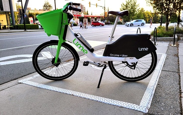
Lime’s e-bike share system is now up and running in the City of North Vancouver.
Hop around UBC with HOPR bike share.
Lots of hills? Carrying a lot of things? Not feeling sporty enough?
What about investing in an e-bike? There are several models, styles, and manufacturers to adapt to your needs. Read about the e-bikes rebate.
Sustainable Transportation Choices
Have you thought about transit?
If you’re travelling through the Metro Vancouver area, consider using TransLink.
Operating 88 transit systems in 130 communities across British Columbia.
For times when you still need a vehicle.
What about carpooling with coworkers and friends?
Did you know there are car-sharing options?

Modo Co-Op

Evo Car Sharing
If you still need your own personal vehicle…
Please be mindful of your trips and try to use as many of the alternative options above as possible.
You are a business owner/employer.
Did you know you can also contribute and offer your employees choices?
Have you thought about a shuttle bus for your employees?
If none of the above convince you, but you still want to do something about your transportation choices, contact us. We’ll be happy to talk to you!
Walkable New Westminster - A short walking tour of the Agnes Street Greenway
Always excited about new infrastructure advancements promoting walkability, we could not wait to experience it ourselves and virtually take you on a tour. As a part of the engagement process, the City of New Westminster has been installing an interim greenway using temporary materials along a portion of the designated route.

Source: www.newwestcity.ca
Image description: Map with the Greenway intervention phases
Happy New Year! What better way to welcome the new year than taking a stroll down the neighborhood. Especially, when it’s a new walkability project!
The Agnes Street Greenway is a part of the City of New Westminster’s commitment to sustainable transportation and climate emergency response. This is a new 1.2-kilometre greenway along Agnes Street to support Active Transportation.
Always excited about new infrastructure advancements promoting walkability, we could not wait to experience it ourselves and virtually take you on a tour. As a part of the engagement process, the City has been installing an interim greenway using temporary materials along a portion of the designated route. The temporary route will run along Agnes Street from First Street in the east, connecting south onto Lorne Street before terminating at Carnarvon Street.
Video shot on relive.cc APP
We took the Phase-1 route. This route connects, in about 15 minutes walk, Queen’s Park with New Westminster Skytrain Station. It is comfortable to walk and a relief from the noisy streets. Owing to the route's elevation, you are treated to great views of the river. We noticed some shared pathways which encourages all road users to be more aware of their surroundings.
The elevation is mostly flat with the exception of Lorne Street where the BC Provincial Court building is located. This area might be challenging due the natural inclination of Lorne and its connection with Agnes by stairs. You might find it safer to share the lane with cyclists in this section because the sidewalk provides access to the Court garages.
If you have difficulty using stairs, we recommend you take a detour through Carnarvon Street until Fourth and then head up back to Agnes. If you are cycling and/or able, you might use the short bicycle ramp/stairway.

Source: BEST
Image description: a mother pushing a baby stroller in front of the Agnes-Lorne intersection
Still under construction, the bike lane intersections look like they will be protected from the vehicular traffic, but they will need to share lanes with pedestrians at certain nodes.
In the images below you can see Agnes-Fourth intersection lined with protected (concrete markers) bike lanes.

Source: BEST
Image description: Provisional intersection Agnes-Fourth
One of the added benefits of this route is that it will expand the mobility choices for the students and staff of the École Qayqayt. The Merivale intersection is a traffic calmed zone (speed limit 30km/h) where the bike lane merges into the curb extension creating a shared space for cyclists and pedestrians.

Source: BEST
Image description: Provisional intersection where the bike lane merges into the sidewalk
Active Transportation allows us to move safely and responsibly in our communities and more so grown in popularity since the pandemic.
So there you have it, our short take on the Agnes Greenway project. Check it our for yourself and we encourage you to share your inputs with the City. It will be considered by the project design team as they create a greenway that is safe, comfortable, and accessible for people of all ages and abilities in this link. Help design your neighbourhood better. More about it here.
Happy walking!
This article is written by BEST’s Isabel Garcia. #walkability

Living Streets on the Amazing Places podcast
Earlier this month, 3-term former Saanich councillor Dean Murdock spoke to Alix Tier from our Living Streets team on his new Amazing Places podcast.
Dean and Alix spoke about how walking should always be a consideration in our communities, and how especially now — in this time of living, working and playing locally — we might be able to encourage communities to make changes to facilitate better walking environments.

Click the image to go to Amazing Places: Episode 4.
Dean asked all the right questions, such as the big one: why focus on walking? As Alix points out, walking is great for our physical health, but especially when the pandemic has led to a work-from-home boom, it's been an important way to maintain mental health and social connections. Staying inside, feeling the COVID-19-related uncertainty, and having to maintain physical distance was challenging for all of us, and continues to place limits on how and where we move about. It has also has allowed walking (or rolling, depending on your mobility challenges) to serve as common ground for all — a democratizing activity, if you will.
How about walking without a purpose? Dean and Alix delve into the many ways we have changed our approach to walking. And not just from the perspective of the ‘average citizen’. Thanks to the creativity of cities and towns across BC, we now see ‘slow streets’ — low-tech engineering measures, like speed humps, raised intersections, or narrowing of roadways, aimed at reducing motor vehicle speeds and congestion in local communities, to make more space and safer walking conditions for people.
As Dean notes, it sometimes also takes political will for local governments to make decisions around transportation changes, even those that are common sense for all the right health and environmental reasons. And as Alix notes, changes that make streets in our communities more conducive to local trips “challenges our thinking, and why we used to make certain decisions and choices about where we shop, where we recreate, and how we interact with the urban realm.”
Take a listen to this episode of Amazing Places.

Seniors' Mobility: Getting Around During a Pandemic
Mobility for senior citizens is important - for shopping, medical appointments, social occasions and continued participation in community life. In the short-term, having older adults drive themselves to avoid COVID risk makes sense. In the longer-term, the liveability and vibrancy of our communities depends on a public transit system to reduce traffic congestion and provide a healthy alternative to driving.
Public transit use has been greatly reduced in the past five months, especially amongst older adults vulnerable to COVID-19. Until there is greater evidence of the safety of public transit use, many seniors may continue to avoid using our bus and train networks for their daily transportation needs.
While some older people may be walking, cycling or getting rides from others inside their social bubble, many are driving their privately-owned cars more frequently, which compounds the trends towards increased dependency on cars that can accompany the aging process.
Mobility for senior citizens is important - for shopping, medical appointments, social occasions and continued participation in community life. In the short-term, having older adults drive themselves to avoid COVID risk makes sense. In the longer-term, the liveability and vibrancy of our communities depends on a public transit system to reduce traffic congestion and provide a healthy alternative to driving.
Economic recovery is, in part, linked to the recovery of the public transit system. Older adults that rely on shared transportation may have better long-term health outcomes if they can avoid social isolation and loneliness that may occur after they no longer hold a driving license.
To rebuild public confidence in the safety of public transit systems, TransLink has introduced a number of initiatives aimed at reducing health risks. High-touch surfaces like seats, poles, handles, and windowsills are regularly sprayed with disinfectant. Many transit riders follow the signs and announcements which encourage the use of face coverings. Mandatory mask rules have not been necessary to get riders to wear masks at this time. Riders are also being encouraged to help maintain physical distancing by planning trips during off-peak times, when transit vehicles are less busy. Hand sanitizer is also available in many transit stations.
In addition to increasing awareness and encouraging use of public transit, BEST is helping provide transportation to seniors so they can attend to medical appointments and many other activities of daily living without having to rely on a single occupancy vehicle. Since early in the pandemic, we have arranged volunteers and paid drivers to deliver groceries, meal kits, prescriptions and laundry services for seniors.
Our Living Streets program, featured above, is also doing outreach to senior-serving organizations to encourage older adults to walk more – for transportation, leisure and recreation and physical/mental health.
If you’d like to get involved with our seniors transportation programs, please get in touch with us.
Vancouver’s Patiotown and Murals of Gratitude Bring New Life to Historic Gastown
Back in 2017, Vancouver began working on Gastown Complete Streets, a transportation plan for the city's historic Gastown neighbourhood, which included the concept of Vancouver’s first car-light area, transit and cycling improvements, celebrating the Musqueam, Squamish, and Tsleil-Waututh Nations on whose territory it was founded, and acknowledging the area’s complex history in relation to indigenous people. Then COVID-19 arrived.
Back in 2017, Vancouver began working on Gastown Complete Streets, a transportation plan for the city's historic Gastown neighbourhood, and an offshoot of the city's Transportation 2040 and Downtown Eastside plans.
The Gastown plan suggested it was time to look into developing Vancouver’s first car-light area, and to look at transit and cycling improvements for the area’s narrow, often cobblestoned streets. The plan would also prioritize celebrating the Musqueam, Squamish, and Tsleil-Waututh Nations on whose territory it was founded, and acknowledging the area’s complex history in relation to indigenous people.
Then COVID-19 arrived.
While the long-range plan was temporarily paused, this past June the city launched its Temporary Expedited Patio Program, as part of the COVID response for the local business community. The patio program allows food and liquor serving establishments to expand their indoor seating outside, subject to their ability to adhere to public health requirements around physical distancing. (The temporary patio permits are free to local businesses, and are valid until October 31, 2020.)
Then in early July, in partnership with the Gastown BIA, the city closed a portion of the 200-block of Carrall Street, considered by many to be the heart of the district's nightlife scene.

Patiotown, as it is now known, consists of many eating and drinking establishments that might be challenged to attract customers in a summer like no other.
Instead, this vibrant stretch of Gastown is now closed to motor vehicle traffic, providing space for public seating, patios, physical distancing, as well as the walking and cycling activity now seen in such significant volumes in cities and towns across BC.
Patiotown now boasts close to 500 outdoor dining spaces, and is supported by The Bicycle Valet, courtesy of BEST, every Friday and Saturday from 5 to 11 pm. (See The Bicycle Valet summer calendar here.)

Need another reason to visit Gastown this summer? Supported by the Gastown BIA, Murals of Gratitude is a volunteer-driven, grassroots public art project which started soon after the COVID-19 outbreak, and has transformed boarded-up storefronts into canvases for local artists. Murals of Gratitude and the murals themselves - which can be seen throughout the neighbourhood — pay tribute to the positive impacts of frontline essential services workers on the Gastown community, and serves as a reminder that we are all in this together.
Visit Gastown’s Patiotown this summer - bring your bike, park it for free with the Bicycle Valet, and enjoy some of the best art, food and drink Vancouver has to offer.

Walking for Social Connection and Mental Well-being
The COVID19 pandemic has led British Columbians to rethink the way we move around our communities and how we inhabit the space within them. With the rise of this ‘new normal’ and Dr.Bonnie Henry’s plea to ‘please go outside’, many municipalities are changing how space is allocated to allow for more accessible opportunities for active transportation -- walking included.
The COVID-19 pandemic has led British Columbians to rethink the way we move around our communities and how we inhabit the space within them.
Walking offers various opportunities for social connection and mental well-being, something many of us might need after weeks of social isolation. Here are a few reasons why walking is good for us and how it can help to improve our overall well being.
Walking helps to promote social interaction and is a great opportunity to connect with others during a time that can be quite isolating for many. Walking with friends, family and neighbours is a great way to remain connected and socialize with your community while maintaining the best social distancing practices.
Walking can help to prevent cognitive decline. This means increased memory, learning and thinking abilities.
Walking 30-minutes a day 3-5 times a week can help to boost your mood and energy by releasing endorphins. As many British Columbians shift to working from home, walking is a great way to take a midday break and come back feeling refreshed and alert.
Consider joining a local walking club in your community or starting one if none already exists. If you prefer walking on your own, but want some extra motivation or sense of community, consider joining one of the Living Streets 2020 online walking groups. The groups can be accessed through either the Strava or ChallengeRunner (challenge code: bc03ru-2d0t) apps.
With the rise of this ‘new normal’ and Dr. Bonnie Henry’s plea to ‘please go outside’, many municipalities are changing how space is allocated to allow for more accessible opportunities for active transportation -- walking included.
Municipalities across the province are doing their part to improve the accessibility to safe walking spaces. Here are a few examples:
North Vancouver: Destination and neighbourhood streets are part of the City of North Vancouver’s Open Streets Action Plan. This initiative has the goal of promoting the health and safety of residents while allowing space for physical distancing.
Kelowna: Downtown streets are being opened up to pedestrians and limited to cars for the summer month, allowing more space to explore the downtown while adhering to physical distancing measures.
Oak Bay: The community has temporarily reallocated parking spaces for pedestrian use allowing more space for physical distancing.
Check out the What’s Happening in your Area page to learn more about how communities around BC are becoming more walkable.
Let us know what your community is doing to promote walking for social connection and mental wellbeing, or about barriers to walking in your community. Fill out the Living Streets Survey.

Local Governments Make More Room for Walking, Biking & Rolling
New spaces for walking and queuing. Re-allocated travel lanes for cycling and rolling. Expanded patios on streets to support the restaurant sector. These are just a few examples of initiatives being introduced by local governments over the past few weeks to support British Columbians, as we all look for ways to get back to commuting, shopping, dining out and recreation…while also aiming to maintain our distance.
New spaces for walking and queuing. Re-allocated travel lanes for cycling and rolling. Expanded patios on streets to support the restaurant sector.
These are just a few examples of initiatives being introduced by local governments over the past few weeks to support British Columbians, as we all look for ways to get back to commuting, shopping, dining out and recreation…while also aiming to maintain our distance.
If the BC re-opening plan is anything like its predecessor (ie. the lockdown plan), it will be a resounding success! If this happens, it will be due, in no small part, to the guidance of the province's Ministry of Transportation and Infrastructure (‘MoTI’).
In May, MoTI introduced a series of recommendations and resources for local governments — essential guidance on the reallocation of roadway space for physical distancing, which has in turn paved the way forward for many communities across BC to take this as a cue to take decisive action.
These measures seem to make a lot of sense, as they not only support health guidelines, but also broader efforts to support the CleanBC plan to reduce transportation emissions. And that means making small but meaningful changes to reduce automobile dependency, and use active transportation to form the backbone of many aspects of public life.
Here’s a small sampling of initiatives introduced by BC communities to meet the challenge. We hope there’s more to come!
Victoria: Vehicle access restrictions, parking realignment, and making space on local streets
Vancouver: Road closures, repurposed road space, and a study of further street reallocations
North Vancouver City: Reallocation of road space on destination and neighbourhood streets
Nelson: Reallocation of on-street parking space for sidewalk 'cafes'
Kamloops: Reallocation of sidewalk and parking stalls for commercial activity
More actions supporting civic changes to enable physical distancing for walking, cycling and rolling, as well as wide variety of economic recovery activity, are underway now! If we've missed something happening in your community, let us know by sending us a note below.
Space Reallocation Tips - Submit Here

Vancouver Sets Climate Targets for 'How We Move'
The Climate Emergency Action Plan — announced just months after City Council declared a climate emergency in 2019 — proposes to mitigate some of the causes and effects of climate change by focusing on providing services and amenities close to where people live. Sustainable transportation plays an integral part of the plan, which is why calls one of its strategic pillars How We Move.
Transportation Enters the Public Consultation Phase of Climate Emergency Action Plan
Between 2007 and 2018, Vancouver did something remarkable. Guided by its Greenest City Action Plan, the city and its residents cut carbon emissions by 12%.

During that time, council and staff began to envision using that plan’s success to inform the next plan, which would become the most ambitious yet in terms of making our communities safer, healthier, and greener.
It would become the Climate Emergency Action Plan — announced just months after City Council declared a climate emergency — which proposes to mitigate some of the causes and effects of climate change by focusing on providing services and amenities close to where people live.
Sustainable transportation plays an integral part of the plan, which is why calls one of its strategic pillars How We Move. As the city states in the How We Move targets and actions document released last month:
We can reduce the number of single occupancy vehicle trips by increasing the convenience of active transportation and public transit and then support the rapid transition to electric vehicles for those remaining trips.
How We Move is all about embracing this next 10-year challenge — accelerating our collective and individual actions to further reduce carbon emissions, and achieve 2030 targets:
90% of people will live within an easy walk and roll of their daily needs.
2/3 of trips in Vancouver will be by active transportation and transit.
50% of total distance driven on Vancouver’s roads will be by zero emissions vehicles.
Actions proposed by the city's Transportation team vary, including transportation pricing in core areas, expanding and improving the active transportation network, improving bus service, and expanding the electrical charging network and its facilities and fleet support.
While we wait for some of these actions to take shape in the city, what can you do?
From now until April 22, participate in the City's Climate Emergency Survey - your feedback will help inform the 5-year Climate Emergency Action Plan that will be brought to Council in October 2020.
Attend the Climate Emergency Online Public Dialogue on "How We Move" - Tue, March 31, 2020 7:00 PM – 9:00
For more information, visit the City of Vancouver’s Climate Emergency Action Plan webpage.

The State of Cycling in Metro Vancouver
On February 28, 2020, HUB Cycling released Benchmarking the State of Cycling in Metro Vancouver, an in-depth report developed in partnership with all Metro Vancouver municipalities and TransLink, the regional transit authority, to provide a snapshot of the extent and quality of the region's bikeway network.
HUB Cycling releases ‘Benchmarking the State of Cycling in Metro Vancouver’ report
Developed in partnership with all Metro Vancouver municipalities and TransLink, the regional transit authority, the State of Cycling report provides a snapshot of the extent and quality of the region's bikeway network.

Over 18 months in the making, the State of Cycling does more than just provide an up-to-date picture of the lower mainland's route infrastructure.
The report shows that in areas where the network has grown and improved, the rate of collisions involving people who cycle has dropped, and cycling trips have increased significantly. It also suggests that where cycling rates are highest, local economies are strongest, pollution and greenhouse gas emissions from transportation are lowest, collision rates involving vulnerable road users are lowest, and health outcomes are the best.
What else does the State of Cycling have to tell us about the growth of cycling in Metro Vancouver?
The region is home to approximately 16,000 bikeways, totalling 4,600 km (almost 200% growth since 2009)
Approximately half of all regional bikeways are rated "Comfortable for most"
From 2006-2016, the region saw a 35% increase in the percentage of commuters who cycle
Among 23 local governments, Vancouver rated highest for ‘supportive policies and practices’’; Surrey boasted the highest proportion of the region’s bikeways (25%)
In addition to providing useful and easy-to-read graphs and charts chronicling the state of Metro Vancouver’s cycling facilities and opportunities for growth, the report also includes a new, standardized bikeway ‘quality ranking’ classification system, and a glossary of bikeway facility types.

Courtesy of HUB Cycling.